Fuerteventura Airport (FUE)
City Orientation and Maps
(Fuerteventura, Spain)
The island of Fuerteventura is one of the largest and most popular of the Canary Islands. Situated to the extreme south-west of mainland Spain, Fuerteventura lies directly south of Lanzarote, its neighbouring island, and to the east of both Gran Canaria and Tenerife.
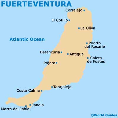
Getting around Fuerteventura is relatively easy and most roads tend to be in good condition. Puerto del Rosario is the capital of the island and home to approximately half of the total population. Just a few minutes north of Fuerteventura Airport (FUE), Puerto del Rosario is an appealing port town with much to offer, being centered around the Calle León and the Avenida Primero de Mayo.
Fuerteventura Airport (FUE) Maps: Important City Districts
Other significant areas of Fuerteventura include the central region, which encompasses Betancuira, Antigua, Páajr and the Calete de Fuste, one of the island's most popular resorts and conveniently located just a short distance from the airport. On the south-eastern side of Fuerteventura you will find the charming fishing hamlets of both Giniginamar and Tarajalejo, while the larger village of La Lajita also resides in this area. Featuring a pebble beach area, La Lajita is home to the Oasis Park, a popular theme park with animals and camel treks.
To the north, the town of La Oliva is worth a visit and was once the capital of Fuerteventura, known for its 18th-century Iglesia de Nuestra Senora de la Candelaria church and accompanying bell tower. Also nearby is the resort of Carralejo, which actively promotes tourism and contains a wealth of holiday apartments, with coastal conditions suitable for a range of water sports.
Spain Map

Fuerteventura Map